Thursday, January 22, 2015

CR2014: Opabin Prospect and Linda Lake

July 24th started with rain, snow, and hail during breakfast. We left our cabin 45 minutes later than usual, and headed for our preferred messy weather destination, the Opabin Plateau, which we had already visited two days earlier. It's a good place to wander when you don't wish to get too high up or too far away.

This photo shows how the bluffs of the plateau appear from lake level.
We decided to walk around Lake O'Hara clockwise to the East Opabin Trail, the longer way to go. In this image Joan and I are at the head of the northern, smaller lobe of Lake O'Hara.
The east trail is wider, wooded, switchbacked, and less interesting than the west trail, but the footing is better in borderline weather. As it was, the rain/snow mix abated as we climbed.

Joan and I were thrilled to encounter a varied thrush on the trail, a bird we never see in Ohio. So even if the image is fuzzy, I'm including it!

We continued on to Lake Opabin, where we ate lunch. The cold persuaded us not to linger. We began our return on the west side of the plateau, and encountered a hermit thrush being pestered by two chicks. You can't feed those beaks fast enough! We also saw the three baby marmots from two days before, in the same spot, but not a parent.

We made a brief stop at the Opabin Prospect even though the rain was developing again. Even with low clouds the view was something to appreciate.
Joan, on far right in the blue rain jacket, provides scale. There's a cairn dead center. Let's take a closer look.
Closer yet.
Then we descended by the West Opabin Trail and returned to our cabin after an outing of five hours.

July 25th began with a cold, light drizzle. Joan and I didn't shove off until 11:00. We were headed for Linda Lake via the Lower Morning Glory Trail and the Linda Lake Beeline Trail (click on the map to enlarge).
This view looks back to the Elizabeth Parker Hut at the start of the Lower Morning Glory.
We lunched at the extensive rock pile on the southern shore of Linda Lake, where we often see pikas.
We briefly saw a couple of pikas, but today's gloomy weather seemed to be keeping them indoors (in their rock warrens).

The clarity of the water here makes for color shadings you wouldn't find anywhere less transparent. The transition from brown to green is sudden.
Joan and I swung around the west and north sides of Linda Lake and hiked down to a four-way junction. Technically the junction is only three-way, but the closed fourth trail is still visible. At one point I slipped on some moss, but the same moss made a soft landing for my posterior. 

At the junction we turned right towards the Lake O'Hara campground. We saw varied- and hermit- thrushes, and heard winter wrens. This trail is much less rocky and root-strewn than the Lower Morning Glory, which we shall remember for the future.

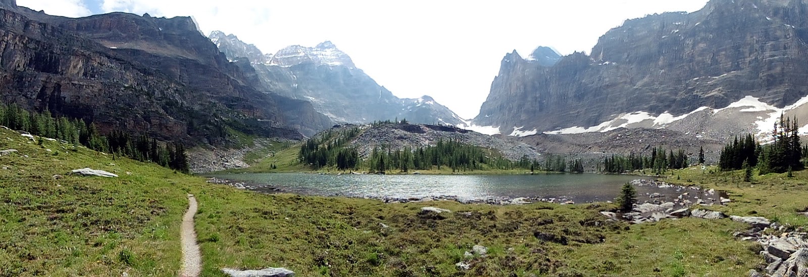
After the campground we took the Cascade Route, which crosses the outflow creek and put us on the east bank of a lake just downstream from Lake O'Hara. It's the small oblong in the above left of this satellite image, almost touching the road.
Here we saw pipits, sandpipers, mergansers, yellow-rumped warblers, a golden-eye duck and six small ducklings. The sightings were exciting through binoculars, but too far for my camera.

After a clean-up in our cabin it was time for dinner. In this photo the gong hasn't rung yet.

Tomorrow the weather should be better.

Tuesday, January 20, 2015

CR2014: Big Larches and Odaray Grandview

On July 23rd Joan and I decided to hike to Lake McArthur by our favorite route, the Big Larches Trail. We find this trail more scenic than the eroded, switchbacked trail that leaves from the Elizabeth Parker Hut. To help you follow today's meanderings, here is a map courtesy of Parks Canada (click to enlarge).

The Big Larches trail emerges from the woods surrounding Lake O'Hara and Mary Lake and skirts the edge of a vast rockfall, where it begins to climb.
Eventually it turns to the right and dives deeper into the larches for which the trail is named.
We passed the trail to All Souls Prospect on our left, then soon, at the outlet from Schäffer Lake, merged with the trail arriving from the Elizabeth Parker Hut. From here, Joan and I took the route to Lake McArthur that passes near the sign-in for the Odaray Highline Trail, established for the benefit of wildlife passing through the choke point of McArthur Pass. To quote Parks Canada,
Adjacent to McArthur Valley and contributing to the corridor is the Odaray Plateau. Habitat here is used seasonally by several species, including grizzly bears and mountain goats. The plateau is closed in summer to protect habitat and to limit disturbance in the wildlife corridor.
The Odaray Highline Trail cuts across the pass, skirting the closed zone. There is a voluntary program to limit the number of groups that use this trail; when we were there, the check-in station requested no more than four groups per day until August 15th, and no more than two after that. This makes grabbing an Odaray Grandview slot difficult, because hikers in the campground can get started earlier then hikers from the lodge. Note: this Parks Canada web page, updated September 2nd, 2014, now requests only two groups until August 15th, and zero after that.

Because the program is only voluntary, we've seen lots of people violating it, but we do not. The bears were here first. This means that we haven't been able to visit Odaray Grandview for several years. (Many wonder at the efficacy of a voluntary program: how much does it really accomplish?)

This year we were lucky. After passing the guard marmot
we checked the sign-in book, and there was an open slot for us! Lake McArthur could wait for another day.

Wanting to do the right thing, we waited to see if any other hikers wishing to take the Highline would show up. We could form a single group, you see, and all could go. And not long afterwards, a group of two moms and four kids arrived.
They decided they would join us. The Highline, after crossing the pass, makes a right turn, wanders through some rocks, and then begins a gentle climb on the lower slopes of Odaray. The view begins to open up.
Then the trail arrives at the point where the Odaray Plateau is closed. The only way to go is up, to the Grandview, on a steep trail that occasionally demands a handhold. However, it's not exceptionally long, and the view at the top is rewarding. Joan and I pulled ahead of the family group, but for some reason I didn't take any photos until we got to the top.

There, the view is a jaw-dropper.
The valley on the left holds the fire road down to the TransCanada Highway. In the middle is Lake O'Hara, surrounded by peaks. A bit further right is Schäffer Lake and a meadow. Visible at far right, in its bowl, is Lake McArthur. Zooming in, my camera can even pick out hikers atop All Souls Prospect!

There are plenty of loose stones of all sizes on the Grandview's bench. Rock piles created by hikers and climbers have gone far beyond simple cairns in the last decade.
Joan provides scale for this stone windbreak, useful for staying warm and keeping sandwiches in hand when winds come howling up the pass.
We ate our lunch up here, and never saw the family group. On our way back along the bench, before the trail starts seriously descending, we saw them arriving at the descent point from the other direction along the bench. Hmm. We had never been over to the other side. Perhaps something was there?

Yes indeed, a spectacular look into the Duchesnay Basin. How could we have overlooked this?!
In the foreground, there's the best view of the Morning Glory Lakes that I've ever had. Beyond a rise, you can see much of Linda Lakes. On the far side of the basin rises Cathedral Mountain, and below it the mixed rock faces and trees of the Cathedral Prospect, which we've hiked before.

On our return descent we caught up to the family group, and we all stopped for a snack. Then we spotted ptarmigans, at least one parent,
and one chick.
We continued retracing our steps to our cabin, and enjoyed another fine dinner at the lodge. On an evening lakeside stroll, I took several photos of "Bob's Bench,"
which I've discussed in detail at the end of this post. My photos of the bench allow Bob to keep an eye on its condition.


Saturday, January 17, 2015

CR2014: Opabin Plateau and Yukness Ledges

Early on July 22nd Joan and I scooted up to the parking area and bus stop for Lake O'Hara. The old, weatherbeaten shelter had been replaced by a shiny new one.
Here's a closeup of the bulletin board, with bilingual notices, warnings, weather reports, etc.
Hey look! Ben Gadd, author of the best-selling Handbook of the Canadian Rockies, will be speaking tomorrow night!
Joan and I boarded the lodge bus, and happily left civilization 11 kilometers behind. This photo is taken from the near the mouth of Lake O'Hara, into the sun.
We decided to head first to the Opabin Plateau, our favorite spot for late starts and rainy days, a great place to wander with no adamant goal. We prefer to head up the West Opabin Trail,
and in this photo, we've come over the lip of the plateau and are looking back the way we've come.
Just a few minutes later we came across a family of hoary marmots. A parent, likely exhausted, was lazily keeping an eye on things.
There were three baby marmots to look after. Here's one, nibbling on the greenery.
And two more, emerging after chasing each other through the tunnels and overhangs of the rocks.
One took a perch.
We tore ourselves away from the marmot playground, and five minutes later, spotted a pika running from rock to foliage and back. It can be difficult to spot this cute little critter in the greenery.
Pikas harvest foliage and create haystacks in their rocky dens to carry them through the winter.
Another five minutes on we encountered another marmot, who checked us out.
Soon we were approaching the final moraine before reaching Opabin Lake. Hungabee Lake is in the foreground.

Here is the layout from Google Maps.

Looking back down the plateau from this point, much is obscured by the gentle downslope.

It was barely past noon, so Joan and I decided to traverse the Yukness Ledges and return to the lodge by the Lake Oesa trail. As we approached the midpoint of the ledges, and came around a corner, we encountered a mountain goat heading towards us. He's still shedding his winter coat (click on the photo to enlarge), and looks raggedy.
We halted, but the goat, embarrassed by his disheveled appearance, decided to abandon the trail.
Of course I had to take the obligatory mid-point photo back to Lake O'Hara. Some of our trail is visible at far right.
Others were traversing the Yukness Ledges, some clockwise, some counterclockwise.
From here my photo-taking ceased for the day.

When taking the Victoria Lake cutoff,
we met Jim and Gabby, two guys we met for the first time a couple of years ago at Lake O'Hara. The regulars do bump into each other from time to time!

Also, as we started down on the Lake Oesa Trail, we encountered a young man coming up who was desperate for AA batteries for his almost exhausted camera. We had none -- our cameras all took proprietary batteries.

It was a gorgeous, creature-filled day. Who knows what might happen tomorrow?

Friday, January 16, 2015

CR2014: From Talus Lodge to A Walk in the Past Trail

July 21st opened with a spotlight on the flanks of the mountains to the west.
Joan and I came up to breakfast to discover that our companion pigs had been playing in the kitchen. Doc Maybe was perched in a lookout spot,
and Percy was balancing on the draining rack!
Bad weather moved in, clouds, fog, and for a while, hail (click on the photo to enlarge).
Clouds came scudding up from the lower valleys.
The helicopter waited out this bad weather; in the end, the delay was only an hour, and Joan and I were not on a tight schedule today. The helicopter came up from the valley and swung around the bowl, rather than popping over the ridge.
The landing included pivoting the helicopter to keep the external storage locker on the same side as the luggage.
Half of a family group (Dad and daughter) were dropped off at the Shark Mountain helipad to pick up their car; Mom and son would fly to Canmore and wait for them.
For this final leg I got a turn in the front seat.
The clouds were still low down here, but they didn't deter an experienced pilot. We were going downhill to Canmore, not up into the mountains.

After disembarking in Canmore and grabbing our bags, we had trouble opening and closing the trunk in our rental car. On investigation the fault turned out to be a pebble wedged into the latch mechanism, which we dislodged.

Joan and I had extra time in the afternoon, so we drove a while up the Icefields Parkway to drink in the landscape.
We certainly weren't the only ones.
Then we returned to the Trans-Canada Highway and drove on to Field, where we would spend the night. There is a trail leaving from the Kicking Horse Campground, called A Walk in the Past.
This is an interpretive historical trail, with printed guides visible in the lower right of the photo. The signs on the trail are easy to find.
The path departs from a flat campground, so we weren't expecting an interesting landscape. However, the trail soon launches into a climb up the flank of the mountain, crosses the railroad and under the TransCanada. It grows into a broader way that follows the steep (4.5%) railroad bed originally used before the creation of the Spiral Tunnels, which reduced the grade to a manageable 2.2% in 1908.

At the end of the trail lies an narrow gauge locomotive, abandoned when the construction of the Spiral Tunnels was completed.
It's a Baldwin 2-6-0 mogul steam locomotive, as described in this plaque (click on the photo to enlarge).
There was a panoply of flowers in one section of the route. Here, a tall white bog orchid.
The indian paintbrush is one of the most widespread flowering plants, and most varied in color, in the Canadian Rockies.
And here is the mountain death camas. As you might suspect, it's not a good idea to eat the flowers.
Impressive in an entirely different way was this tree, bark clawed off by a bear. My walking stick provides scale. I'm glad I wasn't here the same time as the bear.
We returned to our car and checked into the nearby Cathedral Mountain Lodge, where we unpacked. This required precision because most of the floor space is filled with the bed, a short armoire, gas-fired heater, and chairs. After unpacking the minimum amount for a one-night stay, we had dinner at the lodge.

When Joan and I went to bed, it became clear that the cabins have a design problem. They have a high clerestory ("clear story") window facing the porch, which admits light from the strategically placed porch light. The porch light automatically turns on at dusk and cannot be turned off. There is no curtain or other means of preventing the bright light from entering the cabin. It was too high to reach. We finally gave up; I re-dressed and trudged over to the front desk, where the surprised but helpful staff member rustled up a short stepladder, and we successfully turned off the light by unscrewing the bulb a couple of turns. Insulating my hand by a towel, of course.

Darkness properly established, we went to sleep. Tomorrow, Lake O'Hara!