Friday, September 27, 2013

Arctic Journey: Qaqortok

The Explorer approached Qaqortoq as we finished lunch. Qaqortoq is the fourth-largest town in Greenland, with about 3200 inhabitants. Just like Nanortalik, it sprawls around a harbor.
Here in Greenland "taking your truck into town" has a whole new meaning.
In 1993-4 the artist Aka Hoegh presided over the Stone & Man project, aimed at transforming Qaqortoq into an open air art gallery. It attracted numerous artists and there are now 40 works in the town. Several of these were just opposite our dock.


There was also a stand of Greenland's national flower, the Niviarsiaq -- commonly known in North America as broad-leafed fireweed.
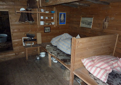
Joan and I joined one of the groups taking a guided tour. One early stop, after the Stone & Man works, was a museum. Here is a room showing typical early 20th Century living for the Greenlanders; the resident Danes usually lived more comfortably.
The top floor is dedicated to Charles Lindbergh, who stayed here during part of his 1933 visit to Greenland, scouting possible routes for transAtlantic flight on behalf of Pan Am. The plane he flew acquired its nickname of Tingmissartoq in Greenland.


Elsewhere there was this display of Inuit costume.
And a display of various styles of that Inuit invention, the kayak.
Then our group moved on to the town fountain, the oldest in Greenland, built in 1927. I apologize to our guide for taking this picture when she was busy answering a question; there will be a better one towards the end.
This is the sign at the nearby fish market.
A vendor is selling seal meat.
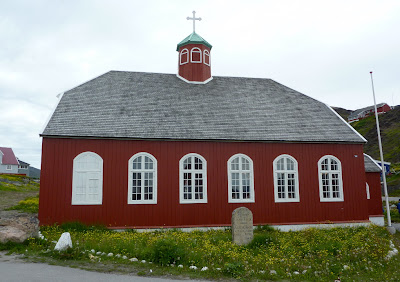
The next stop was the older of two Lutheran churches in Qaqortoq, established in 1832.
We were able to go inside.
Directly adjacent to the church is a small mortuary chapel. This stores coffins (occupied) which can't be buried in winter because of the frozen ground, but must wait until spring. The municipality digs spare graves each summer based on an actuarial estimate, but there are years with extra demand.
Here our group disbanded to allow individual exploration. Joan and I used the provided map to investigate two viewpoints. On the way, we saw this piece of yard art.
The first viewpoint was uninteresting, but the next one provided a great view down to the harbor. The lupine in the foreground is commonly planted here and in Iceland to combat erosion.
Along the way we passed apartment blocks with unusual porch/stairways, and children playing on or with whatever was handy.
Then Joan and I scrambled down the hill to the Hotel Qaqortoq, visible from our viewpoint. At 4:30 there was a Greenlandic Food Tasting, buffet style, at the hotel, and we didn't want to be late. The items on offer included dried cod, whale blubber, lumpfish roe, dried seal meat, smoked Arctic trout, reindeer paté, and more, all of which I failed to photograph. I skipped the blubber and roe, but tasted most of the rest.

After dinner aboard ship we were treated to a performance of traditional Inuit drum dancing, whose origins are at least 4500 years old. These dances can reflect personal expression, be a source of entertainment, and a method of dueling to settle serious disputes. Here our guide from the afternoon stands beside the performer.
I recorded this shorter, one-minute dance. Note that the drummer strikes the edge of the drum, not the stretched skin.


After our guests departed we set sail again, with another worthwhile sunset at hand.
Tomorrow we will visit Brattahlíð, or Brattahlid, Erik the Red's estate and probably the site of the first church in the New World.

Wednesday, September 25, 2013

Arctic Journey: Hvalsey and Norse Ruins

On the morning of July 24th we anchored off Hvalsey, the most extensive and best-preserved Norse ruins in Greenland. There was some ice to admire on the way up the fjord.
The sun was shining into the bridge.
The morning fog/clouds were burning off as we arrived.
Here is our first look at the ruins, from the ship.
The farmstead was established by Eric the Red's uncle, Þorkell (Thorkel) Farserkur, in the late 10th Century. It is also the site of the last documented Norse presence in Greenland, a wedding that occurred in 1408. While there are many theories about the disappearance of the Norse settlements, consider that the Norse managed to live here for over 400 years.

The land is now part of a sheep ranch; in fact, click on the above photo to enlarge and you can just make out three sheep in the shadow of the old church (the largest building).  An eagle and a fox were spotted working on a sheep carcass at the shoreline.

Assisting our landing was a small wooden dock; we wouldn't need to get our boots wet.

There was a weather-beaten sign that included this map of the site (click to enlarge). The legend is repeated in Greenlandic, English, Danish, and German.

It was a short walk up to the area of the ruins.
If you had the oomph to walk around and on top of a small bluff, there was a good overview of the farmstead. The church is to the left and the main dwelling complex is to the right.
This is the footprint of the barn, further to the right than the above photo.
Here we have what is left of the Great Hall.
Approaching the church.
Almost everybody investigated the interior of the church ruins.

On the sunny slopes wildflowers of the low-growing arctic or alpine sort were blooming in profusion, including this alpine or snow gentian.
Which explains what expedition staff member Steve Maclean is doing.
Some took time to admire the view.
Merewyn decided to cool off (?!) with a swim. She's from Canada, but still ...
Then it was all aboard for lunch while the Explorer sailed to Qaqortok.

Sunday, September 22, 2013

Arctic Journey: Prins Christian Sund and Nanortalik

Prins Christian Sund (Prince Christian Sound) is a long, narrow channel that cuts off the southern tip of Greenland, much as the Strait of Magellan saves a vessel from sailing around Cape Horn. We awakened on July 23rd to find the Explorer navigating the sound in a light drizzle.
In places glaciers are still tumbling into the sea.
In this photo the glacial outwash is full of mud, and sharply divided from the seawater.
There are a number of twists and turns to navigate in the sound.
There is one small settlement along the route, Aappilattoq.
There was, of course, ice to admire. Later we would learn that only the week before several yachts had been trapped in the sound for five days.
For those of us who needed an occasional break from helping guide the Explorer there were two morning talks.
We arrived in Nanortalik, the southernmost settlement in Greenland, after lunch. There are about 1500 people in the town and 600-700 in nearby settlements.

View Larger Map
A light to moderate drizzle was falling as I took this photo from the shelter of the sun deck. We were told that the Explorer was the first cruise ship to reach Nanortalik this season because of the ice.
Several activities were scheduled for the afternoon from which we could pick and choose. Joan and I definitely wanted to attend the church choir and the schoolkids dancing, but we had a few minutes to visit the open air museum first. The fellow in charge was enthusiastic and animated, and we would have stayed longer (the museum consists of several different buildings), but the church singing was about to start. The only picture I took was of old and older ice skates.

We backtracked a couple of blocks in the light drizzle to the sole church in Nanortalik, Lutheran, of course, because Greenland came under Danish control in the early 18th Century. At this point Greenland has self-rule except in matters of foreign affairs, defense, finance, and the justice system. The country would prefer full independence but still receives a subsidy from Denmark that amounts to about half the government's budget, we were told.
The interior of the wooden church, built in 1916, was warm and friendly.
Let me offer you a one-minute video of one of the songs.

Two of the elders were dressed in the native Inuit costume. The woman certainly has the colorful advantage here.
After the choir finished it was time to walk up to the school for Kaffe-mik (coffee party, with tea or coffee and Greenlandic cake) while the schoolchildren performed folk dances for us. The dances seemed familiar, because they are derived from dances learned in centuries past from Dutch and Scottish whalers. Square dancers may recognize some steps. In this video, one girl is dressed in Inuit costume, but it's too big for her and she must continually pull it back up.

When the dances had finished Joan and I put our rain jackets back on (intermittent drizzle) and returned to the open air museum. Unfortunately, it was closed and locked, even though our program said it would be open until 7:00. After peering into windows of the museum buildings -- not much to see -- Joan and I began a walk through town.

We browsed in a grocery store to see what we might discover, and our main impression was that the prices were high. Most foodstuffs come from Denmark, and are delivered to Nanortalik by ship; this means that you have Scandinavian prices with a hefty transportation surcharge. We also visited the gift shop, and as a natural consequence of a high cost of living, it was on the expensive side as well. Items made from marine mammals (seals, whales, walrus, polar bears) aren't allowed into the US unless they have proper certification that the pieces are quite old, such as fossil ivory, and even then it's such a hassle that we were advised to refrain from such purchases.

Joan and I reboarded the Explorer, which pulled away from the dock about 7 o'clock. Here is a photo taken as we eased out of the harbor. Note the colorful buildings.

Originally the colors were practical, indicating the function of the building: commercial houses were red, hospitals were yellow, police stations were black, the telephone company was green, and fish factories were blue. Now the colors don't necessarily signify anything, but are a pleasing architectural tradition that enlivens a muted landscape.

There were fabulous pieces of ice in the fjord. Also the sky was slowly clearing.
After dinner there was a stunning sunset to observe.
Zooming in on the distance icebergs with binoculars created a view as if from another planet.
Tomorrow we would travel a thousand years into the past and visit the site of one of the early Norse settlements in Greenland.