
It was an auspicious beginning at the Calgary Airport. Hertz gave us the ideal car for this trip, something we had not received in eight prior visits to Calgary and three rental agencies. The Ford Taurus had a trunk large enough to hold all our luggage, but was not a huge grandfather's land yacht, and best of all, it was not an SUV, which is a battle we've had to fight before. When you are taking a day hike while traveling from lodge A to lodge B, you do not want your luggage exposed to view in the back of an SUV!
We took a long route to Canmore, heading south from Calgary and passing through the small town of Black Diamond to stop at Marv's Classic Soda Shop. Joan and I both had a chocolate malt, and the young man behind the counter chatted with Joan about a trip to Italy he had taken. Then he charged us $5 for the two malts, which listed for $6 each!
We came up towards Canmore through Highwood Pass, which at 7238' is the highest point in Canada on paved highway. South of the pass we passed two young grizzly bears moseying north on the shoulder of the road. These were the first grizzlies we had ever seen in person during our Canadian trips. We had been following the bear situation before our departure, and we knew that it was an active wildlife year. The previous summer was an exceptionally good berry season, so the bear moms had a bumper crop of cubs over the winter. Now, this year, the foraging was not so good, causing the bears and other wildlife to roam widely in search of food.
As before, we stayed at the Canadian Artisans Bed and Breakfast. The guest parking there is flanked by pine trees and the house, as you can see in this photo. Squirrels loved to drop sap-soaked pine cones onto the car from these arboreal perches.

Before hiking, we stopped in town to buy bear spray. Good to have in any case, bear spray had also been required to hike some of the Barrier Lake trails, part of our second hike, at different times in the summer. No bear spray, and you got a ticket. Sometimes that trail had been closed entirely because too many hikers and bikers were ignoring the precautions. Fortunately for us, that trail opened before we arrived.
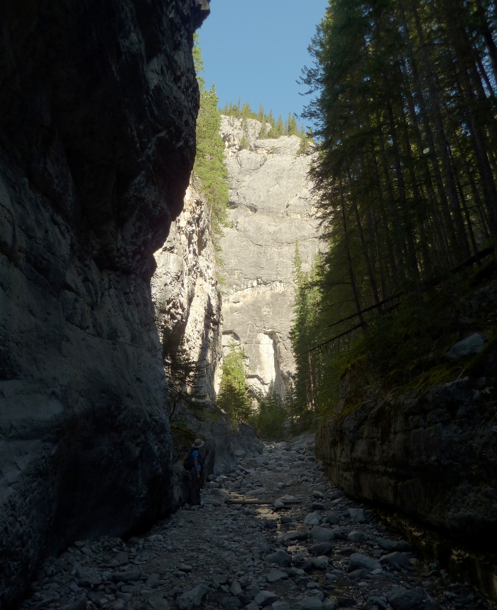
But our first hike was the Grotto Creek Trail in Grotto Canyon. This section remains a fuzzy, low-resolution image on Google Earth, or I'd show it to you. After passing behind a magnesium oxide processing plant, the trail begins to rise and then turns northerly into a gorge. At this point the trail breaks up; it has become just an intermittent alternative to walking the creek bed when the creek is high, and the primary route is up the creek. This is a popular rock climbing location, and it's easy to spot metal hoops hammered into the rock faces. After a while, you arrive at a 'T'.


The next day, a Saturday, we hiked to the Barrier Lake Fire Lookout. Having arrived as early as we could to claim a parking spot, there was a chill morning breeze, and we were glad for our jackets, even on August 27th. We hustled quickly across the earthen dam to stay warm, and then the wide Prairie View Trail began to climb. At the first intersection, where the Stoney Trail, paralleling the lake, crossed ours, we were greeted by an ashen-faced mountain biker. He asked, "Which way are you going?" He had just seen a mountain lion, a kilometer back on his trail. Two young mountain lions, a brother and sister, had been killed earlier in the summer due to their lack of fear of humans. Fortunately we were headed straight ahead.
The first leg of the hike winds up and up the side of the ridge, almost broad enough to be a road, with frequent switchbacks. Several mountain bike riders passed us; this leg is part of a popular loop for them. Eventually you reach the ridge line, and a grassy area provides the first viewpoint.


I neglected to take a photo of the large reflector that is part of this viewpoint. It was used to bounce radio signals around corners and mountains, and might still be active. However, in researching links for this post, I ran across the blog Hiking with Barry, which has a good picture of the structure in his post on this very hike. Barry did a great job with his photos.
It wasn't clear at first how to proceed towards the Fire Lookout, but we had just to continue west on the rocky promontory until the way starts to climb up the ridge again. This walk was turning into a good training exercise for our lungs, which are accustomed to an altitude of 1,000 feet. The fire lookout is at about 6,600 feet, and 2,000 feet above the lake.
The Barrier Lake Fire Lookout is one of the remaining actively staffed lookouts during fire season. Signs request that you do not peer into the house, interfere with equipment, or otherwise disturb the warden.


No comments:
Post a Comment
Comments may not appear immediately as they are moderated by the author to eliminate spam.